4 - Application to Titan
Comparative planetology is a powerful approach when studying remote bodies, especially when only images of their surface are available. This is particularly true for Titan, which shows a complex and rich surface where geological and meteorological processes are active, and where fieldwork is still a dream. It is even more difficult to interpret radar images, which are less intuitive than their optical counterparts, but we only have such (low resolution and noisy) radar scenes to see the surface of Titan through its opaque atmosphere. Studying analogue terrestrial landforms using a comparable radar system (at least in terms of wavelength) can then give us some useful indications and directions to help understand the Cassini RADAR images. However, one has to remain cautious, since the actual origin, age, morphology, and materials of the exotic structures observed on the surface of Titan are not well known. With this in mind, the previous qualitative and quantitative study of the radar scattering of terrestrial linear dunes and mega-yardangs can help us to investigate similar linear structures on Titan. We focus here on some selected sites on Titan imaged by the RADAR instrument, and show how the radar images of terrestrial analogues can guide the interpretation.
Regarding linear dunes, we considered the Cassini RADAR acquisition performed during the T8 flyby in October 2005. This covered the more than 2500 km-long Belet Sand Sea, a region dominated by linear dunes, and stretching from 180ºW to 300ºW and from 20ºN to 20ºS (Lunine et al., 2008). Illumination direction is roughly perpendicular to the orientation of the main axis of the dunes, so that the acquisition geometry is comparable to that of TerraSAR-X images presented in the previous section. Incidence angle during the T8 flyby varied from 17º to 24º, also comparable to the range of incidence angle of our TerraSAR-X data. The RADAR instrument resolution is sufficiently coarse that it can be difficult to determine if the linear dunes in the Belet Sand Sea have sandy interdunes like those in Namibia (Neish et al., 2010), or are separated by exposed bedrock like the Egyptian dunes (Paillou et al., 2014), or if the two kinds can be found in different locations across Belet. We studied ten locations in the T8 flyby, where dune structures are clearly imaged, and performed some averaging in the direction parallel to the main orientation of the dunes in order to extract significant radar scattering profiles. We present three interesting and typical radar signatures in Fig. 7. Site #3 is located in a region where radar-dark dunes end on what seems to be a radar-bright plateau, and where the extracted radar scattering profile looks similar to those observed for Egyptian dunes: a first radar-bright level (−4 dB) corresponds to the rough interdune (the exposed surface of the plateau), a second intermediate level (−7 to −8 dB) might correspond to front sides of the dunes illuminated by the radar, and a third lower level (−12 to −13 dB) could be associated to sides of the dunes opposite to the radar illumination direction. Site #8 is located in a region that was previously studied by [Neish et al. (2010)(7References.md#Neish2010) who applied radarclinometry techniques to estimate dune heights. It shows the same three _Egyptian-like scattering levels: a radar-bright level (−1 to −4 dB) that could again be associated with bare interdunes, an intermediate level (−7 to −8 dB) that could correspond to front sides of the dunes, and a lower scattering level (<−12 dB) that could be associated with back sides of the dunes (and remains higher than the Cassini RADAR noise level, around −18 dB). However, it is also possible that dunes of site #8 are of the Namibian type, and that the radar-bright peaks are the sides of the dunes facing the direction of the radar illumination, the intermediate level being the result of interdune scattering, and the lower level being the back side of the dunes. Interpreting the radar-bright features as interdunes (Egyptian-type) or as sides of dunes facing the radar (Namibian-type) will have a strong impact on the dunes’ shape estimation using radarclinometry (Neish et al., 2010). Site #7 exhibits a more clear Namibian-like bimodal radar signature. It shows alternation of high-scattering return (−6 to −7 dB) and medium-scattering return (around −12 dB): the signature of site #7 looks very similar to that of Namibian dunes, the radar-bright features being sides of the dunes facing the radar, and the medium-scattering level being related to sand-covered interdunes, mixed with the low return of back sides of the dunes. One can also notice that the radar-scattering levels for Titan’s dunes are generally higher than for terrestrial ones, possibly due to some additional volume scattering in a heterogeneous or porous material, as proposed by Paillou et al. (2014). While the low resolution (at best 300 m) combined with the high noise level (around −18 dB) of the RADAR instrument does not allow us to extract unambiguous radar signatures, both scattering profiles of Egyptian and Namibian-type dunes seem to be present in the Belet Sand Sea. Further studies of Titan’s dune fields should then take into account such possible different interpretations of the dark and bright linear features, and evaluate their impact on the understanding of the morphology and history of the structures.
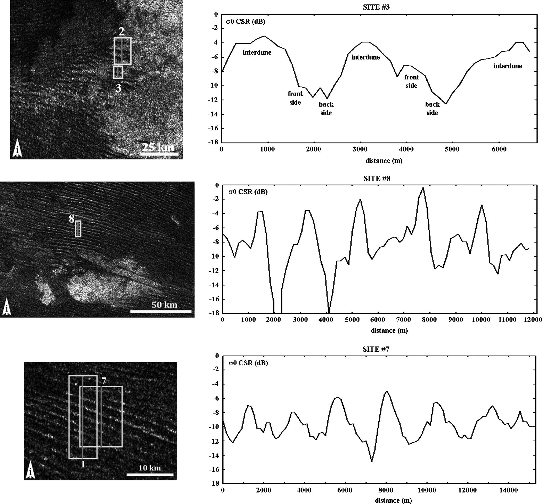 Figure 7: Extracts of Cassini RADAR flyby T8 showing linear dunes of sites #3, #8, and #7 with corresponding radar scattering profiles. Site #3 is located 6.5ºS/238.8ºW with an incidence angle around 21º, site #8 is located 8.8ºS/259.4ºW with an incidence angle around 26º, and site #7 is located 8.2ºS/248.9ºW with an incidence angle around 26º. North is down, the i arrow indicates direction of the radar illumination.
Concerning possible mega-yardangs on Titan, previous work already proposed some candidate structures (Paillou and Radebaugh, 2013 and Radebaugh et al., 2015). We considered two interesting landforms, observed at mid-latitudes during the Cassini RADAR flybys T64 and T83. The T64 flyby was performed in December 2009 (Cassini extended mission) and our region of interest is centred on 41ºN/210ºW with an incidence angle around 14º. The T83 flyby was acquired in May 2012 (Cassini second extended mission) and our region of interest is centred on 40ºN/197ºW with an incidence angle around 12º. Fig. 8 shows two very bright structures in T64 and T83, presenting alternating dark and bright linear features, which are interpreted as possible mega-yardangs. The two landforms are of comparable size, and cover an area of about 60 × 60 km. Four selected sites were studied in the T64 structure and three in the T83 one, crossing bright-dark alternating linear features (see Fig. 8 presenting radar profiles across two representative sites). Again, we averaged the radar scattering along the main direction of the linear features, in order to derive significant radar scattering profiles. While both T64 and T83 candidate mega-yargdangs look similar, a closer look shows that the T64 structure is more like the old mega-yardangs in Chad, while the T83 structure is more similar to the Iranian mega-yardangs. Fig. 8 presents the radar scattering profile associated with site #1 in T64 flyby: as for Chadian mega-yardangs, two main scattering levels are observed, a very bright level (>0 dB) corresponding to possible wide yardang crests, and a less-bright level (around −5 dB) corresponding to possible erosion valleys. Fig. 8 also shows the radar profile associated with site #1 in T83 flyby: the same two radar scattering levels as in T64 are observed there, but with a higher spatial frequency alternation of narrower bright and less-bright features, more similar to the signature of young yardangs observed in the Lut Desert in Iran. We did not conduct any morphological measurements on these potential extra-terrestrial yardangs to compare them to the terrestrial ones (whose morphology is actually poorly described (Goudie, 2007), but we rather focused here on their radiometric signature. As for linear dunes, one can notice that the structures observed on Titan are much brighter than their terrestrial analogues: the brightest crests of Iranian and Chadian yardangs at around −5 dB correspond to the low scattering level of the valleys of Titan’s yardangs. Again, additional scattering processes, such as volume scattering, should be considered on Titan. Nevertheless, even if the global radar scattering level on Titan’s surface is higher, the average scattering level difference between linear dunes and mega-yardangs remains of the order of 10 dB, comparable to the difference observed for their terrestrial analogues. Finally, it is interesting to note that the average radar scattering level of the T64 and T83 structures is around −2 dB (for an incidence angle around 13º), a value comparable to the average scattering level of north polar empty lakes basins (Hayes et al., 2008 and Michaelides et al., 2015). If the radar-bright structures in T64 and T83 are mega-yardangs, they may be the erosion result of unimodal wind direction over soft deposits that could be ancient lake beds and/or evaporites (Barnes et al., 2011 and Cordier et al., 2013). If confirmed, this would indicate the possible existence of ancient lake basins at lower latitudes (around 40ºN) than polar regions in the past history of Titan.
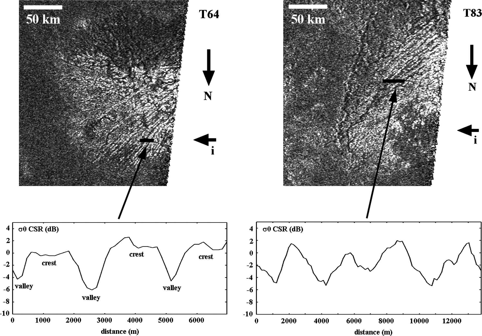 Figure 8: Extracts of T64 (left) and T83 (right) Cassini RADAR acquisitions showing very bright linear structures, interpreted as possible mega-yardangs, together with two studied radar profiles. Resolution is 175 m/pixel, each image covers about 100 × 120 km, T64 yardang is located 41.3ºN/210.2ºW and T83 yardang is located 39.8ºN/196.6ºW, radar incidence angle for both images is around 13º.
While comparing terrestrial geological landforms to ones observed on Titan’s surface is not an easy exercise, the choice of relevant structures on Earth and the use of a high-frequency orbital radar sensor can nevertheless help to better interpret the noisy and low resolution images provided by the Cassini RADAR instrument. In order to illustrate, in a qualitative way, the similarity between the radar signature of linear structures on Earth and Titan, we degraded the four TerraSAR-X scenes that we previously used to a resolution and a noise level similar to the RADAR instrument. Fig. 9 presents the resulting degraded images of linear dunes and mega-yardangs on Earth, which are strongly reminiscent of the landforms seen on Titan’s surface.
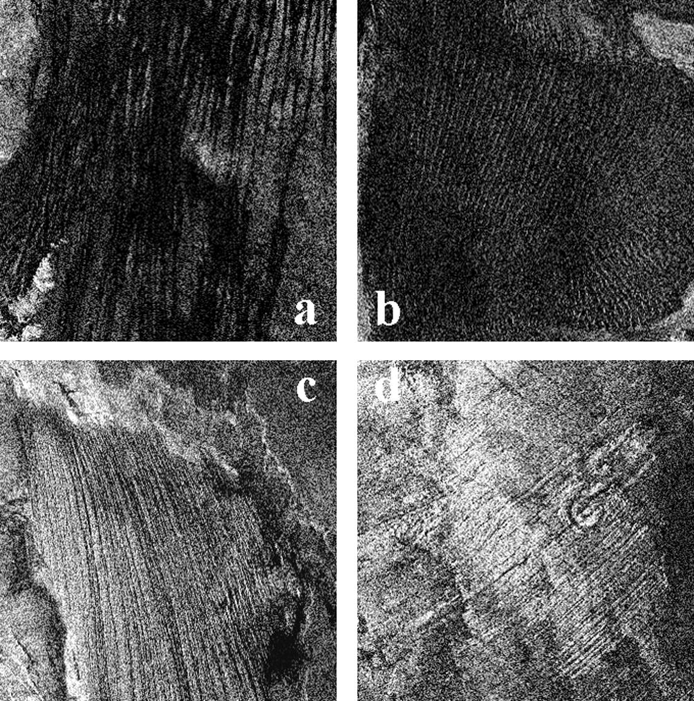 Figure 9: The four TerraSAR-X scenes of Fig. 1 with a resolution degraded to 300 m and a noise level increased to -18 dB. Linear dunes in Egypt (a) and Namibia (b) look quite similar to the structures observed in the Belet Sand Sea, and mega-yardangs in Iran (c) and Chad (d) are recalling the radar-bright structures observed in T64 and T83.