2 - Linear dunes and mega-yardangs on Earth
Linear dunes on Earth are mainly located in arid equatorial regions, and constitute more than half of terrestrial dunes (Rubin and Hesp, 2009). They are formed in a context of moderate sand supply, with bimodal wind regimes associated with seasonal changes, producing quasi-symmetrical and linear dunes in a direction parallel to the one of average annual wind (Bristow et al., 2000). Linear dunes can reach hundreds of kilometres in length, and more than a hundred metres in height, with an interdune separation of the order of a couple of kilometres (Besler, 2008). Such results of sedimentary transport and deposition processes have been observed on all bodies of the Solar System that have an atmosphere: Venus, Earth, Mars and Titan (Zimbelman et al., 2013).
Also belonging to the wind-related linear features family, are yardangs (or mega-yardangs at a regional scale), made of parallel ridges separated by narrow valleys. The latter are formed by the wind abrasion of cohesive rocks (Goudie, 2007). Mega-yardangs are also mainly located in hyperarid regions on Earth, and form under the condition of a strong unimodal wind, that transports sand and gravel eroding soft sediments on a time scale of a million years (Gabriel, 1938 and Ehsani and Quiel, 2008). A favourable condition for yardangs formation is the presence of soft deposits over a harder bedrock, typically observed in areas of ancient lake basins. Mega-yardangs were observed on Mars (De Silva et al., 2010) and might also be present on Venus (Greeley, 1999).
We selected four terrestrial sites to study radar scattering of linear dunes and mega-yardangs. For linear dunes, we considered the Egyptian side of the Great Sand Sea, a large dune field covering 300 × 700 km in eastern Libya and western Egypt (Besler, 2008). The typical length, width and height of dunes in the Great Sand Sea are in the range of values proposed for Titan, the interdune being most of the time uncovered and exposing the underlying bedrock. Egyptian dunes are mainly composed of pure silicate, with a low dielectric constant close to the values reported for Titan’s surface materials (Paillou et al., 2008). They have been used as terrestrial analogues to develop a scattering model that was applied to the study of the radar response of Titan’s dunes (Paillou et al., 2014). The Namib Desert in Namibia (Lancaster, 1989 and Bristow et al., 2000) was also considered for its linear dune fields. It is an arid area which borders the southwestern African coast over hundreds of kilometres, with mostly linear sand dunes presenting sand-covered interdunes, and also comparable in size and morphology to those on Titan. These dunes have been used as a training model for radarclinometry (reconstruction of the topography from the radar signature), with results applied to the study of Titan’s dunes (Neish et al., 2010).
As regards mega-yardangs, we considered the young structures of the Lut Desert in eastern Iran, firstly described by Gabriel (1938) and later studied by Ehsani and Quiel (2008). The region corresponds to a Pleistocene basin with fill deposits (silty clay, gypsiferous sands) and is about 150 km long by 50 km wide, with ridges reaching heights of 100 m (Goudie, 2007). We also considered the older mega-yardangs of the Borkou Desert in northern Chad, formed by erosion of sandstone of Paleozoic age (Mainguet, 1968). This is a region located between the Tibesti and Ennedi mountains, in a corridor of very strong unimodal wind oriented to the northeast. Eroded valleys between sandstone ridges are mostly filled with aeolian sand and present an average depth around 50 m (McHone et al., 1996).
We acquired radar scenes of the four study sites using the X-band radar of the TerraSAR-X satellite, launched in 2007 (Pitz and Miller, 2010). The TerraSAR-X sensor presents two interesting characteristics for our study: (1) X-band is the shortest wavelength (3.1 cm) among available orbital radars for Earth observation, close enough to the Cassini RADAR (2.2 cm) and thus sensitive to the same surface roughness range and (2) its high-resolution (18 m) allows the detailed study of the radar signatures of landforms. We used the TerraSAR-X ScanSAR mode, in HH polarisation, to cover 100 × 150 km areas at an average resolution of 18 m (multi-look images resampled to 8.25 m), with a varying incidence angle from the near to the far range of the image. Acquisition parameters of the four TerraSAR-X scenes are summarized in Tab. 1.
Table 1: The four ScanSAR scenes acquired using the TerraSAR-X radar, orbit inclination is 97º.
| Site – Country | Scene centre Lat./Lon. | Incidence angle range | Acquisition date | Scene ID | Orbit look |
|---|---|---|---|---|---|
| Great Sand Sea - Egypt | 24°30'N / 26°10'E | 19.5–30.0° | 2013-06-06 | 371348705_2 | ascending right |
| Namib Desert - Namibia | 24°30'S / 15°10'E | 24.5–34.5° | 2013-12-27 | 372338466_1 | ascending right |
| Lut Desert - Iran | 30°15'N / 58°20'E | 29.0–38.5° | 2013-06-08 | 371348705_4 | ascending right |
| Borkou Desert - Chad | 19°00'N / 19°05'E | 24.5–35.0° | 2013-12-08 | 372239342_1 | ascending right |
The TerraSAR-X radar scenes are shown in Fig. 1, with relevant full resolution extracts presented in Fig. 2. Both linear dunes of the Great Sand Sea and Namib Desert are roughly north–south oriented and are comparable in size, but they show a different radar signature mainly due to the interdune properties: the bare interdune in Egypt (Fig. 1a) appears brighter than the sand-covered one in Namibia (Fig. 1b), because of the rougher surface associated with the exposed bedrock, which causes a more diffuse scattering of the incident radar wave. Full resolution extracts in Fig. 2a for Egyptian dunes and Fig. 2b for Namibian dunes respectively show some brighter radar returns on the side of the dunes facing the radar illumination, due to the combination of a lower local incidence angle (Blom and Elachi, 1987) and finer dune structures, some of them acting as natural corner reflectors (Paillou et al., 2014). TerraSAR-X’s high resolution also allows us to see the darker back side of the linear dunes, corresponding to a low radar return because of a higher local incidence angle.
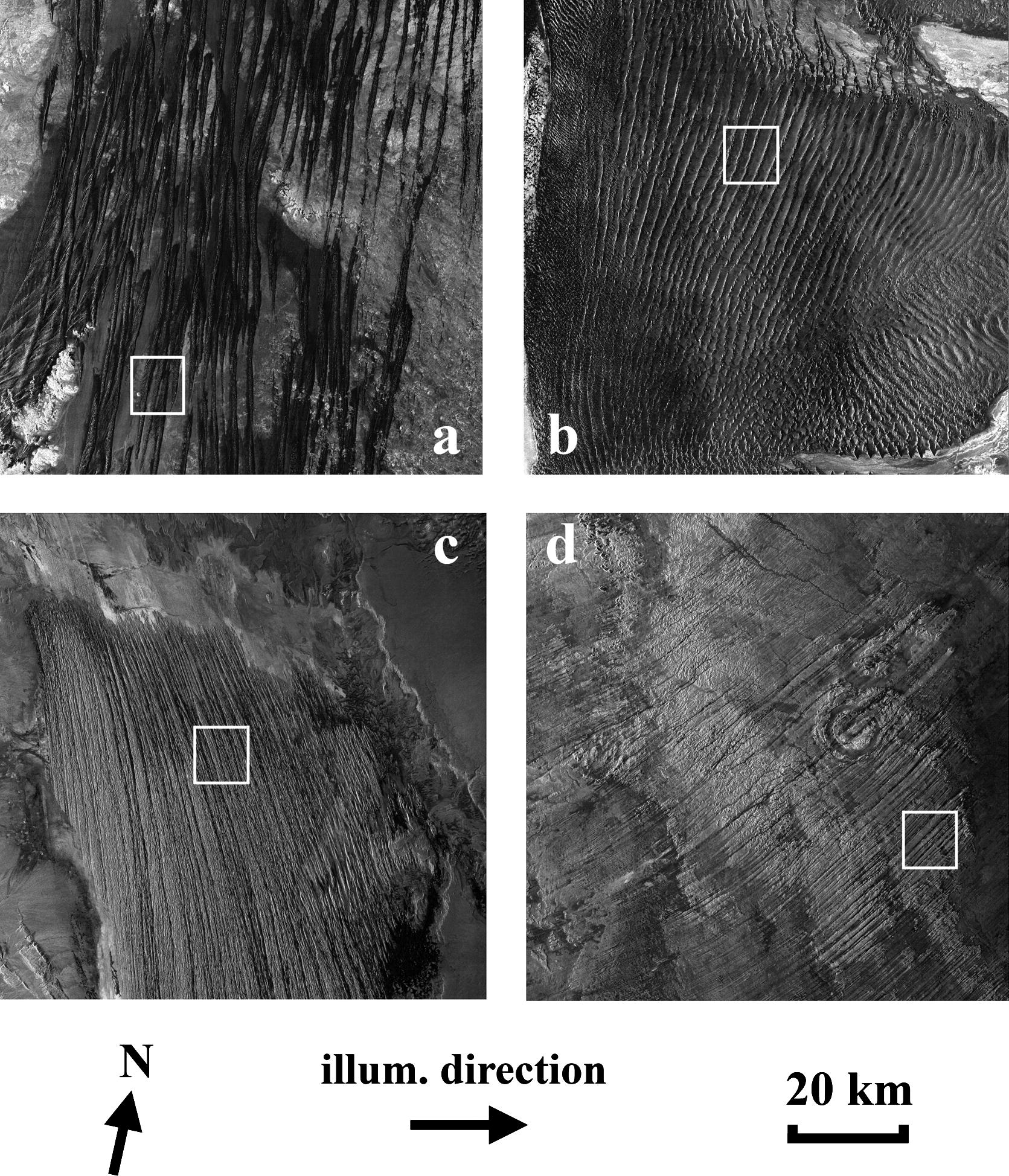 Figure 1: Four TerraSAR-X ScanSAR scenes of linear dunes of (a) the Great Sand Sea in Egypt, (b) the Namib Desert in Namibia; mega-yardangs of (c) the Lut Desert in Iran and (d) the Borkou Desert in Chad. See Tab. 1 for geographical coordinates, white squares show locations of full resolution images presented in Fig. 2.
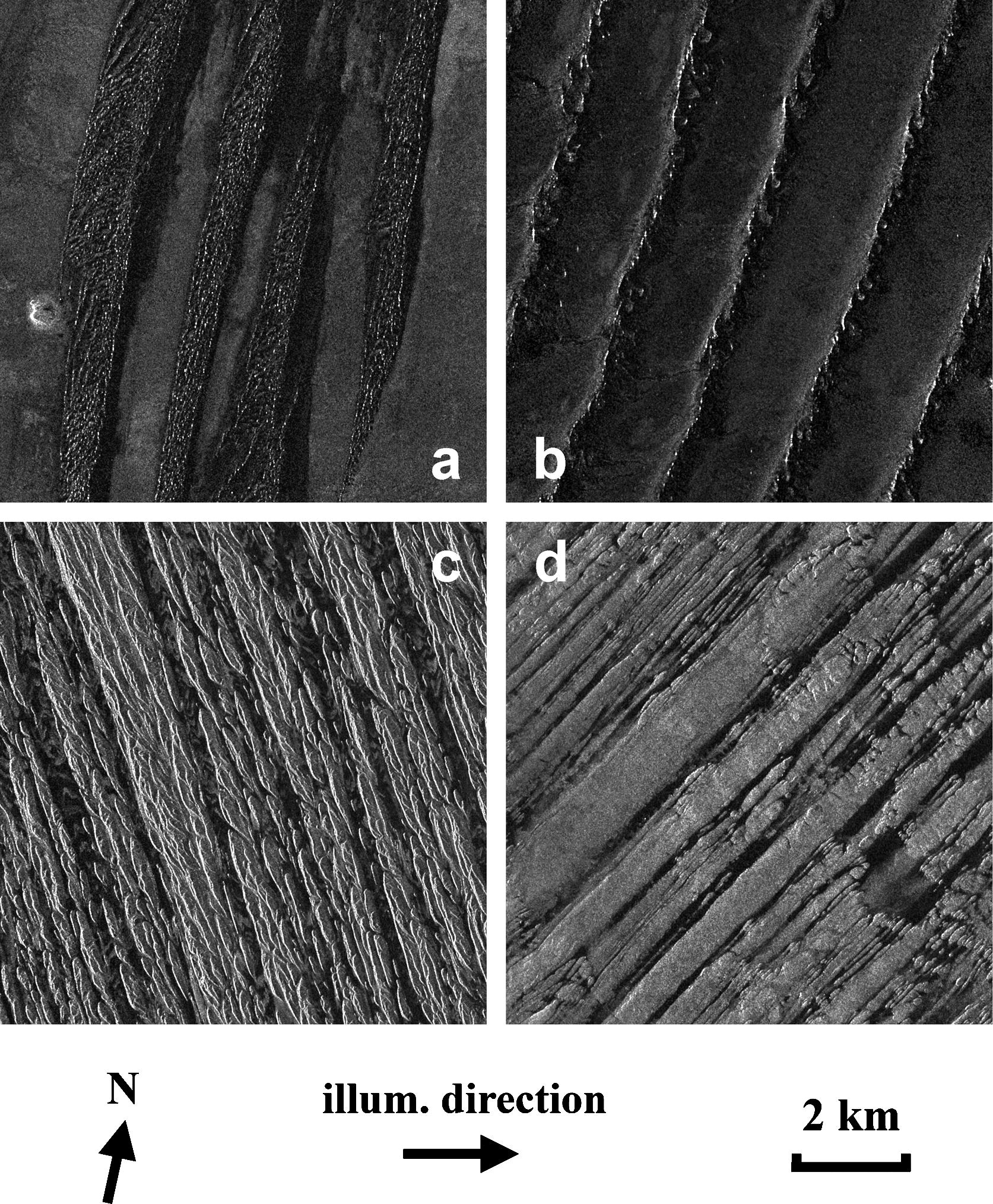 Figure 2: Full resolution (8.25 m/pixel) extracts of the TerraSAR-X scenes: linear dunes of (a) the Great Sand Sea in Egypt (incidence angle 23.0º), (b) the Namib Desert in Namibia (incidence angle 29.2º); mega-yardangs of (c) the Lut Desert in Iran (incidence angle 33.6º) and (d) the Borkou Desert in Chad (incidence angle 33.5º).
Mega-yardangs of the Lut Desert and of the Borkou Desert do not present the same geographical orientation (Fig. 1c and d), but both appear generally brighter than linear dunes: most of the radar scattering is due to the wide ridges of the eroded layer, which is rougher than sand deposits at X-band. Narrow linear valleys separate the ridges and appear darker because they are filled with smoother aeolian deposits (some valleys even contain very small dunes). The young mega-yardangs of the Lut Desert show complex ridges structures alternating with poorly defined valleys (see Fig. 2c), while the older mega-yardangs of the Borkou Desert exhibit a better contrast between wider and flatter ridges and deeper erosion valleys (see Fig. 2d).